Saturday, March 30, 2013

Kentmere Horseshoe

Date : 30th March 2013
Route : Kentmere Horseshoe clockwise
Wainwright's : Yoke, Ill Bell, Froswick, Thornthwaite Crag, Mardale Ill Bell, Harter Fell, Kentmere Pike, Shipman Knotts.
Distance : 20.1 km (12.5 miles)
Height Gained : 1142 m (3748 feet)


The route, clockwise from Kentmere

 Over the previous week there had been more fresh snow over Lakeland. Having glimpsed some of the Kentmere fells from other recent walks and having been advised that the horseshoe is a classic winters walk, I headed off to Kentmere. I arrived at first light, keen to ensure I didn't run out of daylight knowing that progress might be slow depending on snow conditions. The horseshoe route is a classic, taking in 8 Wainwright fells. Clockwise seemed best to me as I knew the terrain on the west of Harter Fell was quite steep and would rather climb up rather than down if conditions were icy. Having parked in a farmers field with an honesty box by Low Bridge in Kentmere, I headed off towards the Garburn Pass.


The lower Kentmere valley from the Garburn Pass near Kentmere


A friendly face

 At Garburn Nook I left the Pass and headed north towards Yoke, the first objective for today. Despite Yoke's impressive profile the path upwards is a fairly gradual ascent with great views east over the Kentmere valley and west over the Troutbeck valley.

The path northwards to Yoke


Looking east over deep drifts (that's a 4 foot wall) towards Kentmere Pike

 Yoke summit is fairly flat with a pile of rocks to denote the top. Views are good all round but the eyes are drawn northwards to the impressive looking Ill Bell.

Yoke summit looking north towards Ill Bell
  
Yoke summit panorama west


Yoke summit panorama east

 Other than a biting wind the weather was perfect and the route onwards to Ill Bell was clear and inviting.


The Langdale Valley area from the path to Ill Bell


The Coniston range from the path to Ill Bell


First glimpse of Kentmere Reservoir


Looking onwards to Ill Bell

 The summit of Ill Bell is an expansive rocky plateau adorned with 3 large summit cairns. Why three? I have no idea but the views from each are excellent. This summit is well worth exploring.


The 3 summit cairns of Ill Bell


Ill Bell summit panorama west


Ill Bell summit panorama east

 The next fell is Froswick which requires a short and steepish descent and then a gradual climb to its summit. Despite its lesser height, the views from Froswick seem superior to Ill Bell, mainly because its small summit does not impede the sight-lines in any direction.


The path to Froswick


Looking back to Ill Bell


Froswick summit panorama west


Froswick summit panorama east


A short video from Froswick summit.

 The snow deepened on the path to Thornthwaite crag making progress rather slow. I quickly learned that the best way of walking on this snow was to either high step in other peoples footprints or better still to go off to the side and walk on untouched snow which had a crust just firm enough to support my weight. Snow near rocks, grassy tussocks or drifts would collapse under foot and I would soon be labouring up to my shins.  


The snow deepens towards Thornthwaite Crag


Looking back to Froswick and Ill Bell

 Anyone who has not visited Thornthwaite Crag before will no doubt be surprised and impressed by the huge summit beacon which must stand about 15 foot tall.


The Thornthwaite Beacon on the summit


Thornthwaite Crag summit panorama west


Thornthwaite Crag summit panorama east


Troutbeck valley from Thornthwaite Crag

 After a short coffee break I followed the path, or rather a line of footprints, northeast towards High Street but having climbed it before, and discovering it is not a particularly good vantage point, I veered off eastwards towards the next objective, Mardale Ill Bell. I was now at the apex of the horseshoe and the views north over Hayeswater and south back down the Kentmere valley were stunning.


Hayeswater and Place Fell beyond.


Onwards to Mardale Ill Bell


Looking back over to Yoke, Ill Bell & Froswick.

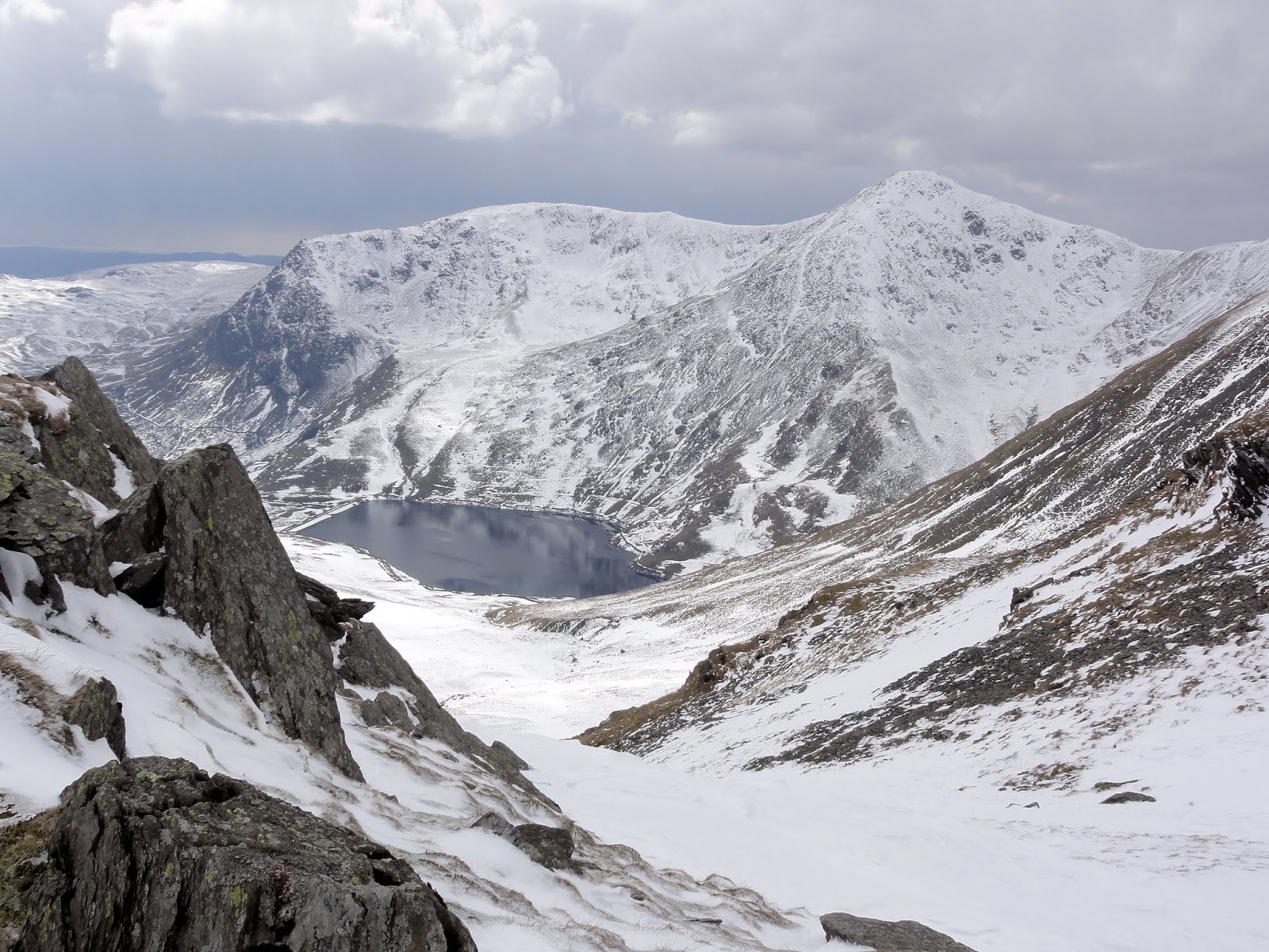
 Mardale Ill Bell summit is a rocky area with great views to the north over Haweswater. The views south are somewhat impeded by high ground. The route onwards to Harter Fell is steep in places descending to the col and very steep in places on the ascent to Harter fell. It was at this point when I put the crampons on and donned the ice axe.

Mardale Ill Bell summit panorama west


Mardale Ill Bell summit panorama east over Haweswater and Harter Fell
Kentmere Reservoir from the Col between Mardale Ill Bell and Harter Fell


The steep route up to Harter Fell


Views looking over a frozen Small Water towards Haweswater


Yoke and Ill Bell over Kentmere Reservoir


Getting steep on Harter Fell. Axe and spikes required


Harter Fell summit panorama west


Harter Fell Summit panorama east

 Although the way south towards Kentmere Pike looked easy enough and crampons were no longer required, the snow was shin deep and with a thin crust which sometimes would take my weight and other times not. This section proved to be the most awkward part of the walk.

Harter Fell view south towards Kentmere Pike


Wrapped up warm


Panorama west from near Kentmere Pike


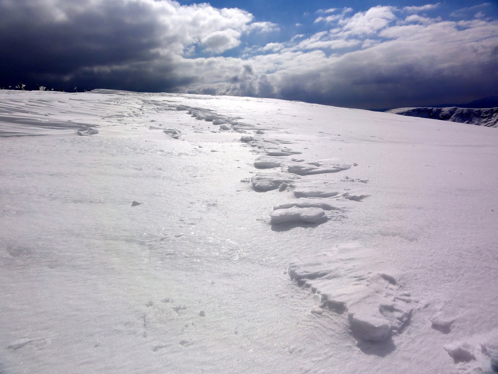
Sistrugi on Kentmere Pike flanks


Kentmere Pike summit panorama west


Kentmere Pike summit panorama east


Windermere from Kentmere Pike summit
 South of Kentmere Pike the snow began to thin out and the going was easier. One more fell to go, Shipman Knotts. 


The path down to Shipman Knotts

Shipman Knotts summit panorama west

Shipman Knotts summit panorama east

Looking back up the Kentmere valley and the days walking route

Panorama of the Kentmere Horseshoe

 This was a great winters walk but it took me nearly 9 hours to get round, mainly due to the snow conditions. I will have to do the route again in summer to get a different perspective of this great horseshoe walk.


Saturday, March 16, 2013

Wansfell, Sour Howes & Sallows

Date : 16th March 2013
Route : 1) from Troutbeck to Wansfell   2) from troutbeck to Sour Howes & Sallows
Wainwrights : Wansfell (Baystones), Sour Howes, Sallows
Distance : Total = 14.87 km (9.24.miles)
Height Gained : Total = 800 m (2357 feet)

___________________________________________


There had been some further snow fall in the lakes over the last few days but the lower fells seemed clear. I had some free time today and wanted to tick off some of the less well known fells in the far south eastern region; namely Sour Howes and Sallows. Wainwright, in book two (far eastern fells) describes these fells as being "not strictly walkers territory" and of Sour Howes in particular he says "it is a fell with no obvious appeal to walkers, and few other than conscientious guide-book writers will visit its summit". Little was he to know that his future popularity would enthuse the 'Wainwright Bagger' to follow in his footsteps over these fells, despite his obvious lack of enthusiasm regarding their virtues. Having been somewhat less than inspired by AW's descriptions, I also intended to climb Wansfell, for which he was far more complimentary. It was therefore 2 walks today, both from the Troutbeck area. The first from High Green up to Wansfell and the second from Limefitt Park up to Sour Howes and Sallows. 


The 2 routes, both anti-clockwise

 Now regarding Wansfell, there seems to be some confusion as to exactly which peak is the official Wainwright. Most folk who climb Wansfell, particularly from Ambleside, will climb 'Wansfell Pike' and be perfectly happy to admire the view before returning, but apparently having never climbed 'Wansfell' as Wainwright described it. Because further along the ridge to the northeast from Wansfell Pike is another peak identified as 'Baystones' on the OS map, but called 'Wansfell' in Wainwright's book. This is the higher fell and looking at his pictorial map, and the altitudes he refers to, there can be no doubt that Baystones is in fact the true Wansfell according to Wainwright and therefore the fell of interest to me. To further confuse matters an area called 'Wansfell' is also indicated on the OS Map a little to the northwest of Wansfell Pike. This 'Wansfell' is not illustrated on the Wainwright map and is, according to OS, of lower altitude than both Wansfell Pike and Baystones. Like I said - some confusion. 

 The Nanny Lane Track is the main route from Troutbeck to the Wansfell region and is an easy going ascent along a good path. About halfway along its trajectory towards Wansfell Pike the path forks and I bared right towards Baystones. At this point the cloud base dropped and it started snowing.


Baystones summit (487 meters) in cloud

The ridge walk between Baystones and Wansfell Pike in low cloud and snow

Wansfell Pike summit (482 meters)
 No views today, so both peaks bagged (in case of any doubt) I headed back down along the Nanny Lane track back to the car. A short drive later I found a parking place in a lay-by near Limefitt Park holiday village. My route took me through the park to join a path which turns south to join the Garburn Pass. Shortly after joining the pass I noticed a stile in the wall on my right from which arose a vague path that seemed to head steeply in the direction of Sour Howes. I followed it upwards to a craggy area identified as 'Backstone Barrow' on the map.

The Garburn Road

Views over Windermere from Backstone Barrow

Sour Howes is up there somewhere
 An indistinct path continues upwards towards the grassy mound of Sour Howes. I was soon back in cloud. The region is largely featureless and in the absence of views today, I trudged on. From leaving the Garburn Road I didn't see anyone until I rejoined it at the end of the walk. This is clearly not a popular walkers territory.

Sour Howes summit in the mist
 On to Sallows next which is northeast from Sour Howes. I decided to take a direct route across the valley between the two fells rather than follow the wall which skirts a ridge to the western side. I couldn't see much due the low cloud but had visibility been better I would most likely have followed the ridge because I soon found myself labouring over an awkward terrain of grassy tussocks.
 
Sallows from somewhere between it and Sour Howes
  Having finally negotiated the 'terrible tussocks' I gained the ridge to the west of Sallows and was rewarded with a view over the Kentmere Fells, the cloud having lifted a little.

Sallows summit panorama East

Sallow summit panorama West

looking South over Sour Howes towards Windermere from Sallows

The Langdale Pikes 'zoomed in'  from Sallows
  I then followed a path northwards to rejoin the Garburn Pass. The clouds had finally broken giving teasing glimpses of higher fells on the walk back down. By this time Wansfell had also broken free of the cloud. Perhaps I should have done these walks the other way round.

Kirkstone Pass from the Garburn Road

Glimpses of Windermere from near the Garburn Road

Yoke and Ill Bell  from the Garburn Road

Wansfell from the Garburn Road
 The impressive looking summits of Yoke and Ill Bell, glimpsed from Sallows and the Garburn Road, convinced me that these would be the objectives for my next hike.

Saturday, March 2, 2013

Beda Fell, Angletarn Pikes & Place Fell

Date : 2nd March 2013
Route : From Hause Farm, near Howtown - clockwise ridge route around the Boredale 
  valley
Wainwrights : Beda Fell, Angletarn PIkes, Place Fell
Distance : 13 km (8.07 miles) 
Height gained : 780 m (2560 feet) 
______________________________________________________________

 In early March there was a slight lull between the two main downfalls of snow in the lakes this year. Snow was still covering the highest fells but below 2000 feet seemed fairly clear. I wanted to stay lightweight today without donning heavy winter gear so decided to explore the southern Ullswater area which seemed fairly free of snow. Parking up near the foot of the Howegrain valley I headed up onto the ridge above Winter Crag and followed this southwards towards Beda Fell.


Starting point Hause farm (top right)


Parking spot by Hause Farm

A glimpse of Ullswater from the ridge to Beda Head

The Boredale valley

 Once on the ridge the going is easy and mainly over grass with height gained gradually. From Beda Fell summit there is a fine view of the less often seen eastern face of Place Fell.


Place Fell from Beda Fell summit

 Further along ridge are the craggy regions of Bedafell Knott and then Heckbeck Head.

Eastern panorama from Bedafell Knott
Western panorama from Bedafell Knott

Fairfield and St Sunday Crag from Bedafell Knott

Angletarn Pikes from Heckbeck Head

 Angletarn pikes are 2 rocky prominences amidst an otherwise grassy landscape. A bit like the Langdale Pikes, they look more impressive in profile from their southern aspects. From the north they look fairly insignificant but the views from each mini summit are excellent.   

Panorama east from the south-east Angletarn Pike

Angle Tarn from the south-east Angletarn Pike summit
Panorama west from the north-west Angletarn Pike


The Deepdale valley with Fairfield at its head, from the north-west Angletarn Pike
Brothers Water and High Hartsop Dodd from the north-west Angletarn Pike
 It is a gentle stroll  from Angletarn Pikes down to Boredale Hause before the going gets steeper on the ascent to Place Fell.

Looking down to Boredale Hause and Place Fell from Angletarn Pikes

 After the short but steep climb up Place Fell the view opens up and you realise that the summit is still a good distance further north and the 'summit' which you have actually gained is a craggy ridge called Steel Edge. 

Panorama west from Steel edge. Place fell summit far right
Grisedale valley with Helvellyn in cloud, from Steel Edge

Patterdale from Steel Edge

St Sunday Crag from Steel Edge
 An easy path follows the wide ridge towards Place Fells summit where an impressive trig point awaits. The views all round are somewhat restricted by the summit plateau and therefore a short detour to the western flanks is rewarded by a most impressive vista over Ullswater to the Helvellyn range.

Place Fell Summit


Place Fell summit panorama east


Place Fell summit view North

Glenridding from Place Fell western summit flanks

Panorama west from Place Fell western summit flanks

The descending path northwards and the lower Boredale valley
 The path back along the ridge is a grassy stroll but I took a steeper detour eastwards at Low Moss to skirt Hollinghow Gill and then back down to the road in the Boredale valley. And so that is Wainwright numbers 70, 71 & 72 for me. Still a long way to go.