Showing posts with label fell walking. Show all posts

Saturday, May 27, 2017

6 Soggy Wainwright's around Bleaberry Fell


Date: 19th May 2017
Start/Finish: Ashness Bridge, Derwent Water
Wainwrights: Walla Crag, Bleaberry Fell, High Seat, Raven Crag, Armboth Fell, High Tove
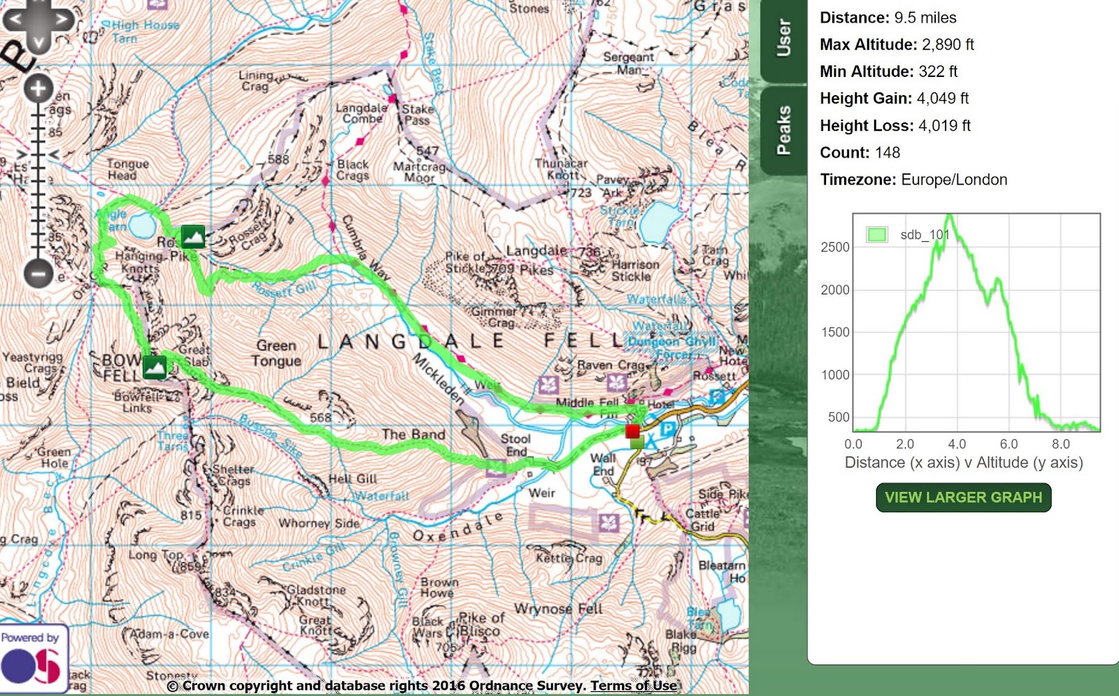
Distance: 12 miles
Height Gained: 3222 feet
Time Taken: 7 hours with plenty of brew stops


The Route: Clockwise from Ashness Bridge car park

This walk is really best done after a long hot summer. Or you might enjoy bog snorkelling, in which case you will be fine at any time of year. I thought I might risk it after the recent spell of dry weather but I was wrong. The whole of the Ullscarf plateau is like a giant sponge of sphagnum moss, peat hags and saturated grass tussocks ... which doesn't make for pleasant walking. I don't mind having wet feet but it is hard work to continually pull your feet out of a gloop that doesn't want to let go. I exaggerate a little. It's not like this all the way round. Indeed my feet were 'mostly' dry up until the area around Armboth Fell. Its just unfortunate that this is large area.

I set off at 6 am, mindful of the forecast which basically said 'great til early afternoon, then rain and possibly thunder'. It's a pleasant stroll from the car park at Ashness Bridge up to Walla Crag. The views over Derwent Water are lovely, and keep improving with height until the best view is reserved for the summit .... which is just how it should be.


Ashness Bridge


Cat Bells over Derwent Water


Walla Crag summit


Walla Crag views over Derwent Water ...


... and over Keswick to Skiddaw


Bleaberry Fell dominates the onward view southwards and its a good path for most of the way. 


Bleaberry Fell


Bleaberry Fell views over to Skiddaw and Blencathra ...


... and over to Cat Bell & Maiden Moor

It's a straight-ish path to High Seat which did involve some acrobatic peat hag hopping in an attempt to keep dry feet.
Being pretty close to the most central area of Lakeland, and being fairly lofty, the views from the summit are extensive. You can see nearly all of the high fells laid out in a sweeping 360 degree panorama.


Views to the Scafell range

Now you could just take the straight path to High Tove and then call it a day but I really wanted to bag Raven Crag and Armboth Fell, as they are temptingly close. So I headed eastwards from High Seat through the progressively squelchy tussocks until joining the land rover track towards Raven Crag. The forestry commission have been busy here and have laid down an extensive wooden path all the way up to the summit. There are signs warning of the dangers of leaving their path due to logging activity, but there wasn't a sniff of anything going on today.


Raven Crag

The Forestry Commissions' 'decking' 


Raven Crag summit 'platform'


Summit views of Thirlmere Dam


Thirlmere

Rather than re-tread my route along the 'decking' back down Raven Crag I rebelliously ignored the warning signs and went 'off path', heading through the pine glade back down the fell. Having survived this perilous ordeal I rejoined the land rover track heading south. From the moment a faint path leaves the land rover tracks to head for Amboth Fell, the terrain becomes increasingly soggy. 

My initial tactic was to stand on the tussocks and hop over the wet moss in an effort to keep my feet dry but before long, first one, then the other foot had sunk above ankle height and my trail shoe shod feet were soaked. At that point the tactic changed to marching purposefully through the sodden terrain and then even taking pleasure in deliberately stepping through the deepest bogs. I know, rebellious eh! Two kilometres of saturated drudgery later, I arrived on Armboth Fell summit which is mercifully a dry raised rocky platform and therefore the ideal place to sit down and have a brew, as unfortunately, there is more splashing and sploshing to be endured on the 'path' up to High Tove.


Armboth Fell summit looking towards High Tove (left) and High Seat (right) ...

... and back over the 'sponge' to Raven Crag

High Tove summit

High Tove views to Ullscarf

Watendlath Tarn

The viewpoint at Ashness Wood

Panoramic view of Derwent Water

So that's 6 more Wainwrights to take the total to 166. I still need to climb Ullscarf and the surrounding fells but I think I will reserve that until the end of our long hot summer. I'm an eternal optimist. 

Wednesday, March 8, 2017

Far Eastern Fells Done and Dusted


Date: 8th March 2017
Start/Finish: Howtown
Wainwrights: Steel Knotts, High Raise, Rampsgill Head, The Knott, Beda Fell
Distance: 13.4 Miles
Height Gained: 3904 feet
Time Taken: 7 1/2 hours

Social Hiking map link

The Route : Clockwise from Howtown
Today was about bagging a straggler. Steel Knotts was the one remaining 'far eastern fell' to be climbed. Its a simple little hike from Howtown which could easily be climbed up & down in 2 hours. I didn't really want to do that though, especially as the weather seemed pretty good; very cold and very windy but clear. So I planned a horseshoe route around the Ramps Gill and Bannerdale Valleys. There are a whole host of Wainwrights around this region. You could potentially bag 11 with only minor detours off this route. I was pressed for time though and the wind was a menace so I bagged just the 5 today.

The foot of the Ramps Gill valley - Steel End on the right

Hallin Fell

Ullswater from Steel End

Steel Knott summit and the route ahead to High Raise

Beda Fell over the Bannerdale valley

Heading towards High Raise on the old Roman road

Still some patches of snow on the flanks of High Raise

High Raise summit views of the Helvellyn range


Views towards High Street

Rampsgill Head views towards Rest Dodd and The Nab

The Knott

Rest Dodd (which I bypassed)

Angle Tarn and Angletarn Pikes (which I also bypassed). Always a pretty picture


Views over to the Deepdale valley

Place Fell

Beda Fell summit


Steel Knotts

A quintessential Lake District picture postcard view to finish a great day in the fells


Tuesday, December 13, 2016

Taking the Boy up Bowfell (AKA the Eiger) via climbers traverse in winter


Video of the walk


Date: 3rd December 2016
Start/Finish: Old Dungeon Ghyll
Summits: Bowfell (2959 feet), Rossett Pike (2136 feet) [and the Eiger! 13,020 feet]
Distance: 9 miles
Elevation: 4076 feet
Time Taken: 6 hours


The Route : Clockwise from Old Dungeon Ghyll (far right)

It had been ages since I was last in the fells. Five months in fact. The main reasons were 1) getting a new job 2) having a child who needs driving to football-lots 3) bad weather whenever I planned a trip. Anyway, it was time make amends. My 9 year old was keen to get out for a hiking adventure and I had promised to take him up Bowfell. Stories of steep crags, exposed routes and stunning views had whetted his appetite and there was also the chance of some snow high up which added to the excitement. 


We parked up near the Old Dungeon Ghyll and headed off through Stool End Farm and up the Band. Patches of snow were visible higher up but the summit of Bowfell remained elusively under cloud. As he had managed Blencathra with ease in the summer I thought that the climbers traverse / great slab route would be good challenge for him, especially if there was a bit of snow around. However, as we didn't have axe's & spikes I was prepared to turn back or change routes if needed 
(I had checked the various web cams, weather forecasts and blogs and was satisfied that any snow/ice would be patchy and avoidable).


Stool End Farm


Oxendale Beck 


A friendly local


Pike O'Stickle


Looking back along the Great Langdale Valley


First patch of snow high up on the Band

We headed up the Band until leaving the main path to access climbers traverse (a detailed description of how to find the route is described here). At this point we encountered the first few patches of snow which the boy promptly jumped in, got his gloves soaking wet and his hands cold. No problem though. I has prepared for such eventualities and had a rucksack full of spare warm stuff. So on went the waterproof mitts and the conversation turned to famous mountaineers and epic alpine adventures. Before long his imagination was fired and we were embarking on the first ascent of the Eiger. He had great fun climbing up a steepish patch of snow using 2 poles and plenty of grit and determination. He felt like a real mountaineer and I was happy that the slope gradually levelled out at the bottom where there were no rocks to slide into if he slipped.  


Struggling up the the Eigers fiercesome north face !  

Up to his thighs on the 'Rote Fluh'


Kicking steps on the 'White Spider'

Having successfully conquered the Eiger we returned to Bowfell and made our way towards the climbers traverse. It was great to take my son along this narrow route which winds its way amongst some of Lakelands most spectacular rock scenery. The presence of a few snow patches added to the adventure. 


Climbers Traverse .....


..... or rather the Hinterstoisser Traverse!


Looking towards Bowfell Buttress


The water spout under Cambridge Crag

A hyperlapse video of climbers traverse


We stopped for a well earned rest and a bite to eat by the water spout at the bottom of Cambridge Crag before heading off for the final push up the steep boulder field by the famous Great Slab.


Views over Great Slab towards the Langdale Pikes


Scrambling up the boulder field


A misty Great Slab

From the top of Great Slab its just a short amble to the shattered summit of Bowfell. Unfortunately there were no views today so we didn't linger. Instead we headed quickly off towards Esk Pike but then got distracted by more large snow fields which just had to be walked over, slid down and jumped in.


Getting back below the cloud and about to 'bum slide' down this inviting slope


Views over to Esk Pike

How Exciting!?

By the time we had finished playing around it was clear that we wouldn't have enough daylight left to climb over Esk Pike and come back via Esk Hause as originally planned. Instead we took a short cut down to Angle Tarn at Ore Gap where even more large snow fields distracted us into further fun and frolics. By the time we bagged Rossett Pike and got down the Rossett Gill path it was going dark. Head torches were deployed for that last mile along the Cumbria Way back to the car. This made for a last bit of excitement before the end of a perfect lad & dad adventure.


Snowball action shot


The arty black and white shot of Angle Tarn


Bowfell summit now out of cloud ..... typical!


Trying to make a snow angel


Icing a limb threatening wound on Rossett Pike summit


Looking down Rossett Gill and back along the Great Langdale Valley

Next on the adventure radar .... The Matterhorn!