I had always intended to finish my Wainwright quest on Haystacks. It was one of his favourite fells and his ashes are reputedly scattered by Innominate Tarn. I have looked down onto its gnarly summit plateau many times from the surrounding lofty fells but have deliberately avoided standing on its hallowed ground until today. I always thought a nice fell to accompany Haystacks in a circular walk would be Fleetwith Pike and so these 2 fells were planned as my final 2.
A video of the 2 day hike can be seen above
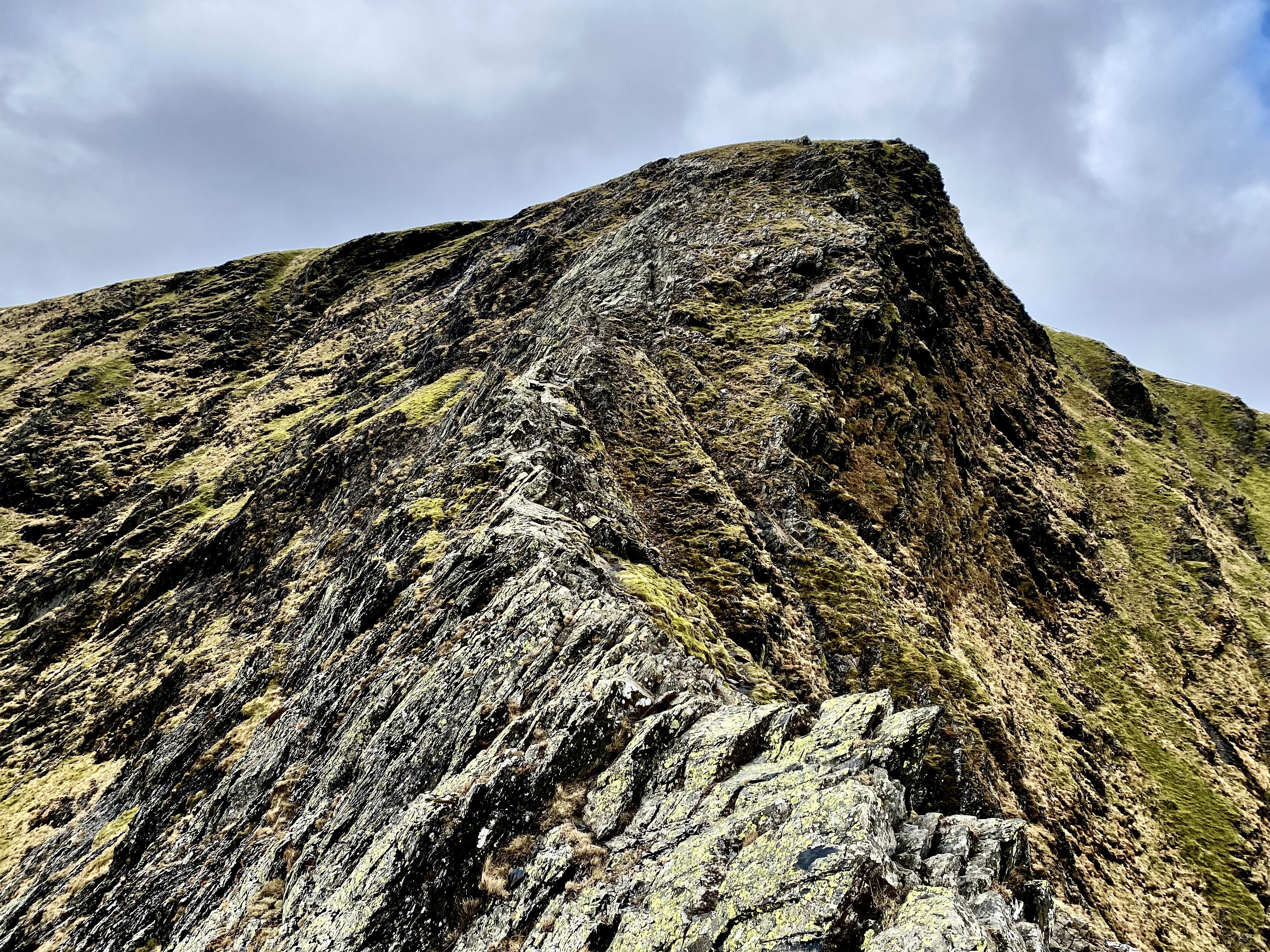
Having climbed Fellbarrow and Low Fell yesterday, I spent the night in the camper van, got up early and drove to Gatescarth by the south end of Buttermere. The plan was to climb Fleetwith Pike up its steep northwestern ridge.
The Steep Northwestern ridge of Fleetwith Pike
It's a good path all the way to the summit taking in some impressive crags and rocky scenery as well as some short sections of scrambling. The backwards views over the Buttermere valley get better with altitude.
The Buttermere Valley
Fleetwith Pike summit view of Haystacks with Pillar beyond
From Fleetwith Pike, a path picks its way southeast before striking one of the old slate quarry paths heading southwest past Dubs Hut Bothy, crossing Warnscale Beck and then turning westwards towards Haystacks. This is a lovely part of the walk as the path meanders through the impressive crags of Haystacks, past Blackbeck Tarn and the lovely Innominate Tarn before heading up onto the impressive summit.
Dub Hut Bothy
Blackbeck Tarn
The Buttermere Valley
Innominate Tarn with Pillar Behind
Innominate Tarn
Haystacks is certainly a popular fell and indeed it entertained a steady procession of walkers including some large groups while I was there. The summit views are magnificent in all directions and only the lack a good prospect of Buttermere is missing. And this is something easily remedied by a short walk to a rocky outcrop over the other side of the lovely un-named summit tarn. From here, the views north over the Buttermere valley are unsurpassed and certainly worthy of 30 minutes R&R.
The un-named Tarn on Haystacks summit
Mission Accomplished
Stunning Views from Haystacks
It was with some reluctance that I finally left Haystacks and headed down the well worn path back down to Buttermere. For most of the way, the whole route taken from start to finish is in view on the right side.
Magnificent Views of Fleetwith Pike from the descent path
So that was my final Wainwright, all done from Lakes level and all on my own. It ends a journey which started on Helm Crag 16 years ago. I blame 10 years of weekend kids football for the lack of timely progress but also my habit of revisiting old favourite fells by different routes rather than getting on with the matter at hand. But eventually they all got done, even if it took me longer than it took Wainwright himself to walk and then write up all 7 of his pictorial guides. But then I'm guessing he didn't have kids football to contend with.
Dates : 1st May 2025 Wainwright's : Fellbarrow (416m), Low Fell (423m) Start / Finish : Thackthwaite Distance : 5.5 Miles Height Gained : 1342 Feet Time Taken : 3 Hours
The Route : Anti-Clockwise from Godferhead
This was a 2 day trip, long planned and much anticipated. The plan was to take the camper van up to the Buttermere & Crummock Water region with the aim of climbing my last 4 Wainwright Fells. This blog post describes day 1 (Fellbarrow and Low Fell). The next blog post describes day 2 (Fleetwith Pike and Haystacks). A video of the whole 2 day hike can be seen below.
The forecast was a warm one. In fact today was supposed to be the hottest day in the UK so far this year. Thankfully the bulk of the warm weather was south of the midlands but even so, I left it late for the hike today in order to avoid getting too hot and sweaty. So I left Preston at 1pm with the intention of starting the walk at about 3pm. It's a vintage van so 60mph is about as fast I can go!
I parked the van in the lovely quiet village of Thackthwaite and then headed up an unusual path up into the fells. The path runs a straight course up to the flanks of Sourfoot Fell and is lined with Oak Trees planted at regular intervals which appear to be a few hundred years old. In years gone by this must have been an important avenue but the reasons for its existence are unclear to me. It terminates at the base of the fells where nothing of any obvious importance resides (now).
Whiteside and Grasmoor from Thackthwaite
The 'Avenue' to the fells by Galloway Farm
The path then bears right, crosses the upper reaches or Meregill Beck and then follows a dry stone wall before vearing off to approach Fellbarrow from the North. The summit is adorned with a fine trig point and has uninterupted views over the Solway Firth to Scotland.
Fellbarrow Summit View South towards Low Fell
It's then a case of following a good path in a southerly direction onto Low Fell. No such trig point here, just a pile of stones but the views are superb. From here you can see the whole of Crummock Water and the Buttermere Valley. In fact the only area of nearby interest missing from the panorama is Loweswater, something cured by a short walk onto neighbouring fell top 'Bield'.
Low Fell Summit View over Crummock Water
Bield View over Loweswater
Stunning Views from the Descent to Thackthwaite
I then headed down and back to the camper van. Overnight 'road' parking is prohibited in the Lake District but you wouldn't think so as there are so many motor homes and camper vans clearly parked up for the night along the shores of Crummock Water and Buttermere. For me, that's just taking the piss. I think if you're going to stay for a night on a public road in the Lakes in your van then at least be discrete and look for somewhere out of sight and off the beaten track. Just stay 1 night and leave the area exactly as you found it. And so that's exactly what I did.
Parked up for the Night
The following morning I moved the van to the Gatesgarth car park at the south end of Buttermere, ready for my final 2 Wainwright Fells.
Date : 25th April 2015 Wainwright’s : Barrow, Causey Pike, Scar Crags, Sail, Crag Hill, Grisedale Pike Start / Finish : Braithwaite Distance : 10 Miles Height Gained : 3835 feet Time Taken : 7 Hours
The Route : Clockwise from Braithwaite
The main aim of this hike was to bag Barrow, which I missed out the last time I climbed the Coledale horseshoe in 2013. On that hike I climbed Outerside and then went on to Causey Pike and the rest of the horseshoe. Barrow was therefore too much of a detour in the wrong direction.
A video of the walk can be seen above.
The path to Braithwaite Lodge
I parked in the lovely village of Braithwaite and then walked up the path towards Braithwaite Lodge. From here a good path heads straight up Barrow and I was stood on the summit about 45 minutes later. The views were magnificent in all directions and offered a great look at the whole route ahead.
The path up Barrow
Barrow summit view of the whole horseshoe
Apparently there is a direct path from Barrow straight up the northern side of Causey Pike but it’s not marked on either the OS or Harvey maps. It also look perilously steep and so I chose the usual route of following the Stonycroft Gill path as it heads between Outerside and Causey Pike before another path exits on the left side and cuts back up towards Causey Pike.
The summit of Causey Pike is a truly magical place to be on a clear day. The views are extensive in all directions. I spent a good 10 minutes there … just looking.
Causey Pike summit view northwards towards Skiddaw
Causey Pike view of the onwards route
The stroll along the ridge to Scar Crags is a nice respite for weary legs and is equally rewarding for the views over towards the Newlands Fells.
The Newlands Valley
The last time I climbed Sail, the path was badly eroded. The following year, the fix-the-fells team repaired the path. The manner of repair has come under some criticism as it is essentially a gravel path rather than the stone pitching technique more commonly employed in the upland fells. It also takes a distinctive zig-zag route from bottom to top which looks unnatural and has been described as an eyesore by some. I leave it for you to decide.
The Zig-Zag path up Sail
Crag Hill from Sail
The path up onto Crag Hill is steep and rocky. Much more like it ! But the summit is a large flat grass and stone plateau from which you have to walk to its periphery to appreciate the best views. The trig point, which had been demolished the last time I was there in 2014, has now been rebuild and looks resplendent again.
Crag Hill Summit
Crag Hill represents the apex of the horseshoe. You can extend the walk over to Wandope, Grasmoor and Hopegill Head but I’ve climbed those fells before and so I kept to the traditional route. I therefore headed to Coledale Hause and then up to Grisedale Pike.
The view back down the whole horseshoe from Coledale Hause
Onwards to Grisedale Pike
The view from Grisedale Pike is a fine one in all directions. I was lucky to have it to myself for a few minutes until others arrived and so I moved away. Nobody likes a summit slug !
Grisedale Pike summit view East over Derwent Water …
South West over towards Crag Hill and Grasmoor …
West towards Hopegill Head and Ladyside Pike …
and North towards the Coast
As I headed down the steep descent path, I passed 3 mountain bikers carrying their bikes up ! Nutters !
Views towards Keswick …
and Braithwaite
So Barrow was Wainwright number 210. Just 4 to go !
I've climbed Blencathra twice before, but never the surrounding fells. And so todays objective was to remedy this and climb all the fells in the Blencathra group, as well as Blencathra itself via Sharp Edge. I'd chosen a circular route from Mungrisdale and set of at first light on a cold, clear day.
Sunrise near Great Mell Fell
Its a nice gentle stroll up to the summit ridge of Souther Fell along a good path though the bracken. The summit is just a slightly higher grassy mound from all the others on the summit plateau.
The path up Souther Fell
View of Blencathra from Souther Fell Summit
A good path follows the western shoulder of Souther Fell until it drops down to the Glenderamackin valley. Another path then follows the flanks of Scales Fell up towards Scales Tarn.
Looking up to Sharp Edge and Foule Crag
Scales Tarn
From Scales Tarn there is a clear choice of routes up onto Blencathra summit. An easy path can be followed to the south, or the more challenging route along Sharp Edge and Foule Crag can be attempted. If the weather is inclement, particularly if wet and/or windy then I would strongly suggest the easier option.
Sharp Edge & Foule Crag
Looking back along the ridge
Sharp Edge is a common site of hiking accidents which unfortunately includes 12 fatalities since records began in the 1940's. As such, it is a region firmly on the radar of the Keswick mountain rescue team. Accidents usually occur as a result of slipping on the smooth, polished rock along the ridge, particularly an awkward sloping rock which hikers call the 'bad step'. In wet weather it can be treacherous. Today however, the conditions were fairly calm and dry underfoot.
Every Step along Sharp Edge
Once sharp edge has been safely traversed, the difficulties are not yet over. Facing you is a angular rocky outcrop called 'Foule Crag'. This is a hand and foot scramble which demands 10 minutes of further concentration until the summit plateau is reached. Then you can finally relax and enjoy a pleasant 5 minute stroll up to summit of Blencathra where stunning views in all directions are an ample reward for your efforts.
The next objective was the somewhat bland and uninviting grassy mound of Mungrisdale Common. For those who have no desire to 'collect Wainwrights' then I would advise avoiding the 90 mins of torment required to cross, and then re-cross the boggy terrain in order to bag this particular summit. Your feet and knees will certainly appreciate it.
Mungrisdale Common is the grassy lump in the mid ground
The summit of Mungrisdale Common
Bannerdale Crags is the next fell on the route. As it is approached from the western side it looks decidedly un-craggy, as the drama is hidden from view on its east facing aspect. This was a perfect place to stop for a brew and a bite to eat.
Bannerdale Crags summit - looking back towards Blencathra
Bowscale Fell is clearly visible to the north and a good path arcs around the head of the Bannerdale valley to reach it. The return path drops down to the valley and follows Bannerdale Beck back to Mungrisdale Village.
Bowscale Fell summit
This hike brings the Wainwright total to 198. The next hike will tackle the 4 fells to north of Blencathra which will then complete the Northern Fells.